Deconstructing Ankara’s revisionism
Seeking to deconstruct Turkey’s revisionism as expressed this week regarding Greece’s sovereignty, the Foreign Ministry has issued and distributed 16 maps tracing the course of Ankara’s positions and claims over the last 50 years to all embassies and Greece’s permanent representations abroad.
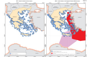
Tellingly, the map from 1972 shows that Turkey had made absolutely no claims undermining Greece‘s sovereign rights on islands and the continental shelf or challenging areas of responsibility and other areas under Greece’s jurisdiction.
The maps underscore the gradual escalation of Turkey’s claims between 1972 and 2022.
In a letter to the diplomats, the secretary general of the Ministry of Foreign Affairs, Themistoklis Demiris, stressed that Turkey’s revisionist stance hails back to the 1970s, when it began granting licenses for research on the Greek continental shelf.
This, he said, intensified in the 1980s with Ankara’s attempt to snatch the responsibility for Search and Rescue (SAR) away from Greece.
In the 90s moreover, Ankara went as far questioning the ownership of land – i.e. islands and islets in the Aegean – describing them as having undesignated ownership.
More recently, in the 2000s, Ankara granted other exploration permits in the Eastern Mediterranean.
In 2019 it came up with the Turkish-Libyan maritime border memorandum and since last year it has directly linked the demilitarization of the eastern Aegean islands with their sovereignty.
The 13th map depicts the innovative way in which Turkey draws the median line with Libya, ignoring the intermediate existence of Crete.
Indicatively, the first map highlights the situation in 1923, when under the Treaty of Lausanne, Turkey relinquished sovereignty over all islands within three miles of the coast of Asia Minor except Imbros, Tenedos and Lagouses.
The second map depicts the situation in 1972, when Turkey claimed nothing other than six nautical miles in the Aegean and 12 nautical miles in the Mediterranean and Black Sea.
Another map, the sixth, shows the official adoption by the Turkish state of the “gray zones” theory regarding Greece’s sovereignty in the eastern Aegean.
The 14th map depicts last year’s Turkish theory that Greece must demilitarize its islands or else have their sovereignty challenged.