Scientists harvest fresh findings from roots of Santorini volcano
A team of Greek, American and British scientists are involved in a project to better understand the deep roots of Santorini’s volcanic system. Analyzing the data obtained two years ago during a marine research expedition, the scientists have reaped valuable knowledge about the submarine area, a veritable treasure trove for seismologists and volcanologists, and while the results won’t help us to predict seismic events with the precision meteorologists can forecast the weather, they can indicate which areas are more prone to such events.
The team’s findings were recently published in science magazine Tectonophysics. The findings are based on research conducted aboard the Marcus Langseth, the most sophisticated seismic vessel in the world’s academic fleet, which traveled to Greece from the US for this project in 2015. The lead scientists of the Proteus project are professors Emilie Hooft and Doug Toomey of the University of Oregon, and Evi Nomikou, from the Geology Department at Athens University.
Deep analysis
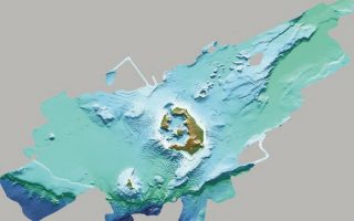
Thanks to the vessel’s state-of-the-art equipment, the scientists were able to produce new high-quality maps of the seabed. Their research is centered around the basin west of the Christiana islets southwest of Akrotiri, and extends all the way up to the basin of Amorgos. “For the first time, we’ve mapped active fault lines in the area between Santorini and Amorgos,” says Professor Nomikou. “This is valuable information. Look at the recent earthquake on Lesvos. One of the problems there was that the fault which produced it wasn’t mapped. That’s how we know that the area east of Santorini is more active than that to its west.”
Deep analysis through the mapping of the seabed has produced lots of information. “In the area between Santorini and Amorgos, we found two underwater landslides, which may be related to the 7.4 magnitude earthquake that struck the region in 1956 and produced a tsunami. Knowing this is vital for those who specialize in studying tsunamis because they can use this information for simulation models,” adds Nomikou. As has been proven, volcanic activity is centered around Kolumbo, an active undersea volcano about 8 km northeast of Cape Kolumbo on Santorini. “We mapped a total of 26 volcanic cones and even found an old one between Milos and Santorini, which is an area we have yet to study in more detail,” says the professor.
Mapping the depths around Santorini has revealed “underwater terraces” resembling those found above the sea surface on many Cycladic islands, used for cultivation. “Systematic research will reveal whether these terraces formed out of a gradual deposition of materials by the volcano or if they’re deformities of the depths formed by the Minoan era eruption,” says Nomikou. Mapping the seafloor is a costly task. “You need an oceanographic vessel with state-of-the-art equipment,” the Greek academic explains. “Most of Greece’s active fault lines are under the sea, so mapping the seabed is imperative if we want to have a better understanding of them.”