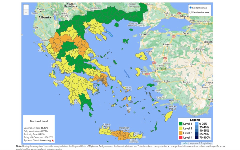
More areas turn orange on Greece’s Covid map

Central, northern and western parts of Athens, along with the broader areas of eastern and western Attica and the port city of Piraeus have all gone up one step before the highest coronavirus transmission alert level (red or Level 4) on the updated epidemiological map of Greece that was presented on Thursday.
They are joined at Level 3, color-coded orange, by Grevena in northern Greece, Ioannina in the west and Larissa in central Greece, as well as the islands of Salamina and Paros.
Infection numbers are also rising at another 16 regional units, which went up to Level 2 (or yellow) on the map presented by Deputy Civil Protection Minister Nikos Hardalias at the Health Ministry’s daily briefing on the course of the pandemic. They are: Karditsa, Lassithi, Messinia, Andros, Achaia, Kozani, Tinos, Preveza, Zakynthos, Syros, Lesvos, Thessaloniki, Thesprotia, Arkadia, Kefalonia and Aetoloakarnania.
The municipalities of Ikaria, Leros, Kythnos, Lefkada, Milos, Serifos, Antiparos and Chios also went up a level to yellow.
The only municipality to show an improvement and to drop to the lowest alert level, 1 or green, was Leipsoi in the eastern Aegean.
Health authorities are also keeping a very close eye on transmission rates at four of Greece’s most popular holiday islands – Mykonos, Ios, Paros and Santorini – as well as in the municipalities of Iraklio and Rethymno in Crete.
Areas that continue to deteriorate to reach Level 4 will likley face localized lockdowns and other measures to contain the spread of the virus.


