Fighting fires from space using instant satellite imagery
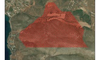
More than 2,300 hectares of land was scorched on the island of Kythira this summer, according to FireHub, a real-time fire monitoring service provided by the National Observatory of Athens’s Natural Disaster Relief Center.
The blaze on Kythira was one of the worst fire disasters this summer. Other big fires this year occurred in eastern Mani, in the southern Peloponnese, where the Kotronas fire burned 1,850 hectares at the beginning of July. Another big one struck the area of Kalyvia, eastern Attica, in late July, followed by a wildfire on the Saronic island of Spetses just days later.
FireHub also measures the extent of damage to burnt areas. According to the service, nearly half the land charred by the Kythira fire was shrubland, while more than a third was agricultural land.
“The rapid mapping of these areas is made possible by spatial resolution images that are constantly being taken around the clock by satellites operated by BEYOND.” The National Observatory of Athens’s BEYOND center monitors natural disasters in Southeastern Europe. It processes data gathered by six to seven satellites at a time, which deliver high spatial images. The most technologically advanced satellite among them is Sentinel-2A, which collects images of land surfaces at 10-meter resolution. All of these images are processed in the fire monitoring system nearly instantly,” explains Dr Haris Kontoes, the director of BEYOND.
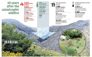
The precise mapping of land burned by wildfires has added importance when it comes to reforestation, compensating those who’ve suffered property damage and defense against flash flooding. BEYOND is teaming up with the European Space Agency’s Copernicus program to assess the risk of flooding, landslides and soil erosion in areas damaged by particularly large fires.
Maps created by FireHub are not just useful after a fire has been put out. They also aid efforts to monitor and fight fires as soon as they start by providing frequent, high-resolution images from above, which helps firefighters get a better sense of its direction and speed. “Our system has a direct connection with the fire brigade. Our satellites scan the entire territory of Greece every five minutes, identifying heat emissions.
If a fire is detected and confirmed by a second satellite, the fire brigade is notified. Satellite observation has provided timely information on fires in remote areas, mountains, border regions, and on the progress of reforested areas,” says Kontoes. The recent fire in Kalyvia, which came close to populated areas, was detected within 10 minutes and the fire service had already begun to receive images of the blaze.
“The effort began in 2007, but back then it took a long time to compile information from the satellites with information provided by firefighters on the ground. Now we have a system that’s gained worldwide recognition,” says Kontoes. In 2014, BEYOND received the first international award from the European Commission and the European Space Agency as part of the Copernicus competition.