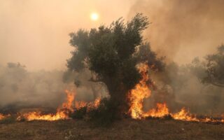
40,000 hectares burned in wildfires in 3 days
Over 40,000 hectares were destroyed in wildfires the three days from August 19 to 21, according to a report by the National Observatory of Athens.
Based on the preliminary analysis of satellite data carried out by observatory’s Meteo weather service, 38,000 hectares were destroyed in Evros and 1,200 hectares in Rodopi, northern Greece; 800 hectares on the island of Kythnos and 500 hectares in Psachna, Evia.
The data may be revised as higher resolution satellite data becomes available.
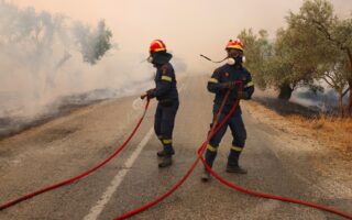
Meanwhile, Copernicus, the EU’s Earth observation program, has been activated for the immediate mapping of the areas in the municipalities of Thiva, Livadeia, Distomo-Arachova-Antikyra in Viotia as well as Chalkida and Dirfys-Messapia in Evia that were burned in wildfires on August 21.
The purpose of the activation is the production of maps and data of the affected region, to assist the work of agencies involved in dealing with emergencies and managing the consequences of the fire.
The service was activated following a request from the general secretary of civil protection.
The data and maps of the Copernicus Emergency Management Service will be made available directly by the General Secretariat for Civil Protection to all stakeholders free of charge for the performance of their duties.
Today, our #RapidMappingTeam has received 3⃣🆕 activations for #wildfires🔥 from #Greece 🇬🇷 ‼️
There are now 4⃣ activations running in parallel:
▶️#EMSR686 & #EMSR689 in the East Macedonia & Thrace region
▶️#EMSR687 in the Sterea Ellada region
▶️#EMSR688 on #Evia Island pic.twitter.com/7esDCvoMff— Copernicus EMS (@CopernicusEMS) August 22, 2023