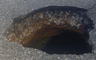
Landslide underlines need to map caldera’s slopes
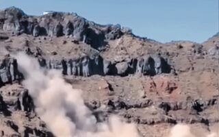
The landslide on Saturday morning on Thirasia next to Santorini has highlighted the need to map the slopes of the caldera on both isles to identify the most dangerous points.
According to scientists, the very nature of the caldera – steep slopes – as well as the composition of the rocks increase erosion and often lead to such phenomena. However, they clarified that construction on the caldera does not increase landslide risks.
“Obviously, incidents like Saturday’s are no surprise to geologists and engineers,” explained Vassilis Marinos, a professor in the National Technical University of Athens’ Geotechnics Department.
“It’s something that could happen in many parts of the caldera. It’s an area with special morphology and its rocks alternate between hard and soft materials. There comes a time when, due to the erosion of the softer materials, some piece, large or small, detaches and slides down,” he added.